Updated August 18, 2005
Created June 6, 2005, last updated August 18, 2005
The final major contract for the Katy Freeway expansion was awarded in March 2005. Two large contracts were awarded in January and February 2005 for sections between Loop 610 and Beltway 8. This is where most of the right-of-way clearance will occur and where most of these photos were taken.
Construction is proceeding at breakneck speed. Between April 23 (when the original photos were taken) and August 13 (when the update photos were taken), a tremendous amount of progress has been made in construction. Right-of-way clearance is also proceeding rapidly. Most of the larger structures are already cleared, including the Igloo factory and the La Quinta motel. Two of the larger remaining structures are the Wellesley Inn and Suites and the REI store.
August 13, 2005 photos

The Wellesley Inn is one of the larger remaining structures. It is located at 7855 Katy Freeway,
on the south side of the freeway just east of Antoine.

A front view of the Wellesley Inn.

A side view of the Wellesley Inn. Grafitti artists have left their mark.

Next door to the Wellesley Inn is a mini warehouse storage facility. The front part
of the warehouse is being dismantled, but most of the warehouse will remain.

This is the location of the former La Quinta motel on the south side of the freeway
between Chimney Rock and Antoine. (see photos taken April 23 for pre-demolition views)

Just east of the former La Quinta motel is the 59 Diner, which is living on borrowed time.
A MacDonalds just behind the 59 Diner is also still intact for now.

This is the location of the former Igloo factory at the northwest corner of the Katy Freeway
and Beltway 8. The last remaining rubble was being cleared. (see photos taken April 23 for
pre-demolition views)

This is a view of location of the former Town and Country Mall
at the southeast corner of the Katy Freeway
and Beltway 8. It was demolished earlier
in 2005. The mall demolition project was not related to the Katy Freeway construction.

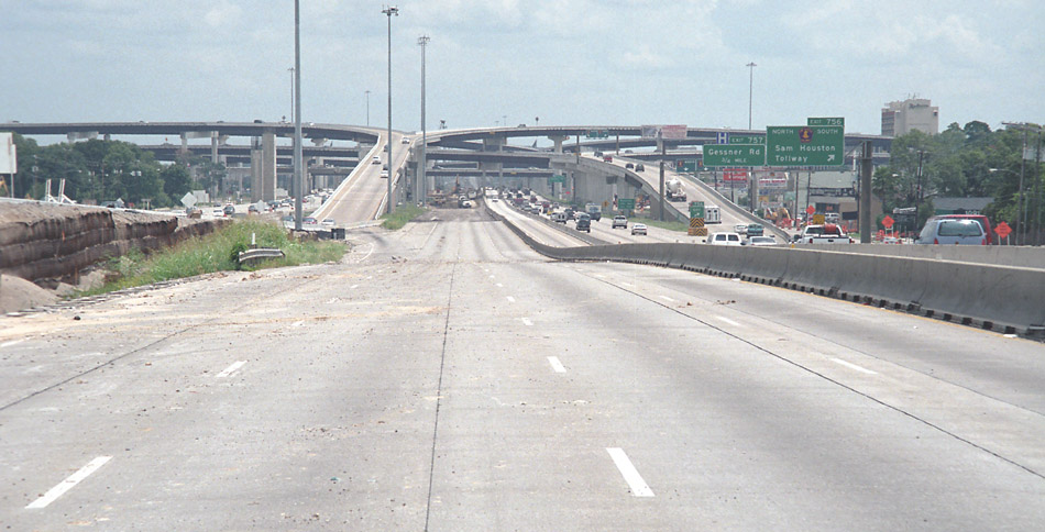
This view looks east from the Wilcrest overpass along the abandoned original westbound main lanes.
Westbound traffic has already been shifted to the new lanes to the left of this view.

This view looks west at the Wilcrest overpass showing the partially demolished original freeway
structure on the left and the new structure on the right.
April 23, 2005 photos

This is the former REI store near Antoine. Update: still intact of August 13, 2005

Just to the west is a former car dealer, Memorial 1 Motorcars. This building is not secure and has
been infiltrated by homeless people. Update: demolished as of August 13, 2005

Here we can see a makeshift bed and plenty of garbage. Most of the garbage is fast-food packaging from the next-door
Whataburger. The homeless people are good Whataburger customers.

Here is another view inside the Memorial 1 Motorcars building.

Just west is another boarded-up building. I think this was a restaurant. We can see the Whataburger
in the background. It will go, too, but it appears to be staying open as long as possible. The
homeless people are surely glad about that! Update: demolished as of August 13, 2005

Next in line is the La Quinta motel. It looks like the roof is being dismantled, but that was actually
done by unauthorized scavengers. They just showed up one day and started taking the tile roof apart.
At that point, La Quinta posted a security guard on site 24/7. Update: demolished as of August 13, 2005

Here we see a corridor of the La Quinta with all doors and windows boarded up. The security guard keeps
an eye on the place. He told me of his run-ins with the homeless people. Apparently communication
is very good among the homeless - they know exactly which buildings are available for their use and
which buildings have scavengable material.

Next in line is the El Tiempo Cantina. The freeway is to the left. Update: demolished as of August 13, 2005

Here is the freeway view of the El Tiempo Cantina.

Crossing over to the north side of the freeway, here is a view of the high-voltage towers and
the high masts. Both will be removed. The power lines will go underground, and the masts will be
replaced with new masts.

This is the location of the former residential street Bunningham. All houses are cleared. The
westbound frontage road will be located at the point the photo was taken.

At Campbell, the right-of-way boundary is marked with this sign.

Old Katy Road starts at Campbell. Here we can see that it has been converted to one-way operation, similar
to the westbound frontage road that will replace it. We can see in the distance that a structure is in
the way.

This is the Ciros restaurant, now closed. The colorful signs say Moved 9755 Katy Freeway.
Update: Ciros and the entire adjacent shopping center demolished as of August 13, 2005

Here is a small cleared lot. There will be more of this.

The gasoline station at the northeast corner at Gessner is closed and awaiting clearance.

This is the Bennigans at the northeast corner at Beltway 8. In the background a connection ramp can be seen.
Update: demolished as of August 13, 2005

A closer view of the Bennigans.

The largest structure to be cleared is the large Igloo factory at the northwest corner of Beltway 8.
I heard it will be a retention pond, but I'm not sure. Update: demolished as of August 13, 2005

The main entrance is now for demolition workers.

Here is a view of the Igloo office building.

Here is the loading dock along the Katy Freeway.

This row of townhouses near Kirkwood was vacated and about to be cleared.

Unit 167 was mostly gutted on the inside.